FAQs
- Deliver value for money for rate payers and the Federal Government
- Deliver a bridge design that:
- Is compliant with standards
- Provides for safe vehicle, pedestrian and cycling access
- Includes, where possible, aesthetic features that are important to the community
- Minimises and manage project risks and impacts
- Deliver information and project updates that are timely and informative
- Ensure that community concerns are listened to, considered and responded to.
- Consolidation of land titles including Crown Land and Council’s road reserve that have been approved by the Surveyor General’s office
- Modelling the impacts of various bridge designs on river flows and flood scenarios
- Confirmation of requirements for cultural heritage approvals
- Confirmation of approvals required under the Marine and Coastal Act
- Assessment of approvals required for historical heritage
- Completion of removal of telecommunication assets off the current bridge and reconnection through under-river boring.
- Appointment of experienced consultants to undertake terrestrial and aquatic environmental assessments
- Appointment of technical consultants to complete geotechnical analysis of river soils and sub-surface conditions that are required for bridge engineering design and construction methods
- Development of outline documentation and specifications for a Design and Construct public tender
- Management of bi-monthly independent structural inspections of the current bridge condition and twice weekly visual condition assessments
- Funding applications and funding management of the secured $5 million Federal Government grant through the Safer Local Roads and Infrastructure Program
- Development of detailed project management plans and project management processes, roles and responsibilities.
- Department of Transport statutory design and construction standards
- Independent flood modelling based on a number of different bridge designs including height, abutments and number of piers.
- Construction methodologies that consider the site, location, constraints and desired timeframes
- Provision of critical water assets for the town of Port Fairy that are currently connected to the existing bridge
- Provision of a safe pedestrian footpath and bike access as part of the new bridge
- Connection to the existing road and footpath network
- Ongoing maintenance and longer-term renewal.
- Bridge Closure Management Plan
- Traffic Management Plan
- Construction and Environmental Management Plan
- Risk Register and Risk Management Plan
- Emergency Management Plan
- Communication Plan
- Marketing strategies
- Council’s Facebook and Instagram pages
- The project page on Council’s Engage Moyne website where you can register to receive notifications to page updates and post any questions you may have about the project
- Council’s newsletters
- Resident and business mail outs
- Communication via meetings and emails with local business and community groups and associations
- Council has also convened a Gipps Street Bridge Community Reference Group (CRG) that provides for two-way communication on the project, hears community concerns and ideas and guides communication and information flows. See CRG meeting agendas and minutes on the Engage Moyne project page.
- Project signage including QR codes to the Engage Moyne Page
- Regular updates to the project plan and key project milestones.
Why is the bridge being replaced?
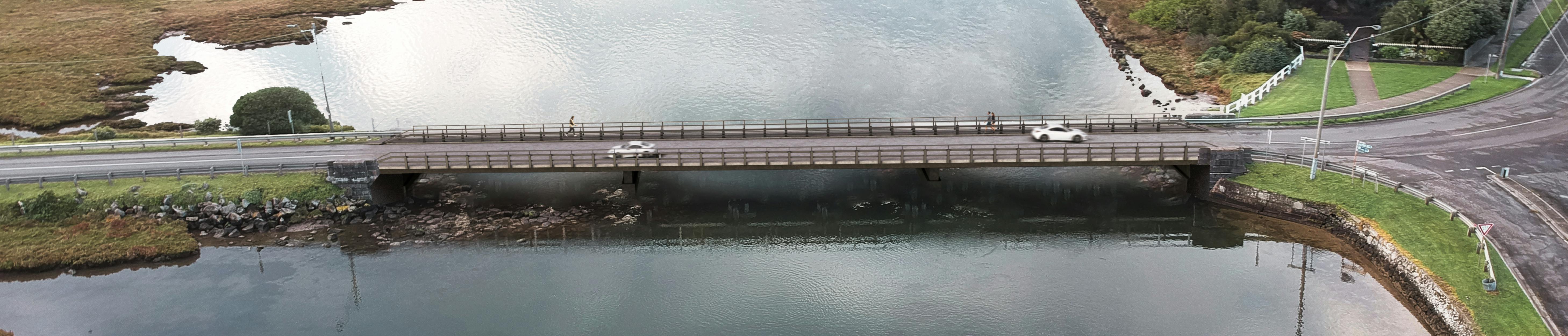
The Gipps Street Bridge that crosses the Moyne River in Port Fairy is the last remaining wooden bridge structure in Moyne Shire. The bridge is a critical piece of transport infrastructure for residents, businesses and visitors with over 4,000 vehicle movements per day during the quieter months of the year and over 10,000 per day during peak visitor periods.
The bridge was built over 120 years ago and is nearing its end of functional life. The condition of the bridge is such that repairing or replacing component parts is not a viable option to retain the bridge as a safe and functional transport asset.
Council is therefore working towards a full demolition of the current structure and construction of a new bridge and associated works.
What does the overall project look like?
The bridge project is one of Council’s largest and most complex infrastructure projects. It involves a range of statutory and regulatory processes and approvals including but not limited to the Marine and Coastal Act, historical heritage, cultural heritage, statutory planning, land ownership and management, works in waterways, environmental management, Department of Transport requirements and ensuring we work in partnership with key utility providers to maintain critical services to the community over the life of the project.
Works not only include the demolition of the current bridge and new construction but also planning and design of connecting footpath and road reconstruction, utility service relocation off the current bridge, traffic and construction management planning, funding and budget management and coordination of external technical experts and services.
Council’s project team are systematically working through project planning, approvals and works assessments to ensure that Council’s regulatory responsibilities are being addressed.
How is the project being funded?
The project is being funded through a $5 million grant from the Federal Government’s Safer Local Roads and Infrastructure Program, with a further $2.76 million from Council.
This allows for project planning, technical assessments, permits and approvals, utility relocation, detailed design planning, bridge demolition and construction, connecting road and footpath reconstruction and other project delivery activities.
Who is managing the project?
The project is being managed by a senior Council project team comprising the Manager Project Management Office and Assets, Manager Engineering, and Manager Operations. An internal Project Control Group (PCG) has been established with representatives from these departments, as well as planning, environment, economic development, tourism, finance and communications.
The senior project team also provides weekly and as-required updates to Councillors and the Executive Leadership Team.
Councillors and officers are committed to ensuring that project planning, management and outcomes:
What project planning activities has Council undertaken so far?
Officers have been systematically working through project planning, approvals and works assessments to ensure that regulatory responsibilities are being addressed.
Key tasks completed to date include:
What will the replacement bridge look like?
A concept design of the new bridge has been developed. The proposed design is based on a number of factors and considerations including:
What are the timelines for the project?
A project plan has been developed that provides for a logical sequence of project planning, design and construction works. The project plan has considered time of year for construction to manage the impacts on local and regional events, the visitor economy and local businesses.
Forecast key achievements to deliver the project are shown in the project milestones. These will be subject to review and update as the project progresses. Council is currently forecasting construction commencement April 2027.
What will happen when the current bridge is demolished?
Council acknowledges that the construction of the new bridge will have major impacts on neighbouring, local and regional residents, visitors, local businesses, emergency and other local services, local and regional events and Port of Port Fairy users.
Until Council has been to market through a public tender process for a bridge Design and Construct contract, it is difficult to determine just how long the works will take from demolition to partial or full bridge opening.
Based on the experience of other similar full bridge replacement projects, it is possible there will be no access across the Moyne River for at least six months - if not longer. However, this is an estimate only; more will be known once submissions to the Design and Construct tender are assessed.
Closure timeframes will be influenced by a number of factors including construction methodology, site conditions, component manufacturing and supply, technical, engineering and quality controls and sign offs and a range of other factors.
As part of project and construction planning, Council in partnership with stakeholders, will develop a suite of management plans including but not limited:
How will Council keep the community informed about the project?
Council will provide regular updates on project progress, milestones, notifications and other key project information through: